|
|


Search Colesberg
Accommodation
Colesberg travel information.
Province: |
Northern Cape province |
|
Routes: |
N1, N9, R717, R58, R36 |
|
Aerodrome: |
No airport – small aerodrome, private planes only. |
|
GPS: |
FACB Coördinates |
|
Latitude: |
S 30° 43′ 20″ |
|
Longitude: |
E 25° 05′ 78″ |
|
|
||
Make sure of the current state of the strips before starting your flight plan. |
||
Tourist information: |
||
Where is Colesberg Situated?
The town of Colesberg is situated in the Great Karoo in the Northern Cape. It is on the N1 approximately halfway between Johannesburg and Cape Town at the foot of Coleskop. This makes it the ideal stop over spot when travelling between Cape Town and Johannesburg. Colesberg is also situated on the N9 on the Port Elizabeth Knysna Road.
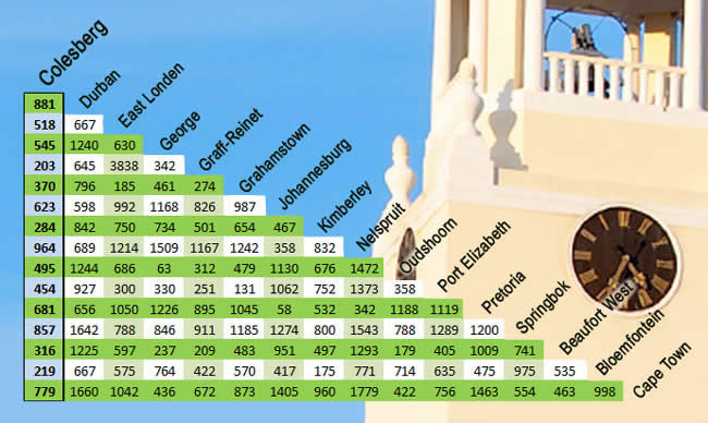
Distance from nearby town to Colesberg |
|
Hanover |
74Km |
Donkerpoort |
36Km |
Trompsburg |
113Km |
Bloemfontein |
226Km |
Noupoort |
53Km |
Middelburg |
93Km |
Philippolis |
56Km |
Norvalspont |
32Km |
Petrusville |
90Km |
Hopetown |
174Km |
Colesberg distance map to:
Colesberg is centrally located for overnight accommodation.
If you have information to add please contact us.
Use all information on this site at own risk. If you find information that needs to be updated, please contact us immediately.
Photos © 2014 by tourism photographer BerendPhotography.com / web & design by: eapproach.co.za